The borough plan preferred option consultation has been delayed until after the county council elections. I suspect the vast housing & employment targets will require the loss of land at the edge of Bedworth Woodlands. The latest assessment of countryside in the borough shows parcel NB21 to be the least “constrained”. In English that means the one at greatest risk. Adjacent parcel NB20 also scores lower than many other potential sites. This may be why it is impossible to publish the consultation paper at this time.
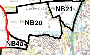 NB20 This parcel of land is defined by Bedworth Lane to the north; Woodlands Lane to the east, development at Bedworth Heath to the south and the borough boundary to the west.
NB21This parcel is defined by field boundaries along the boundary of the Green Belt designation to the north, the A444 to the east; Woodlands Road to the south &
west.